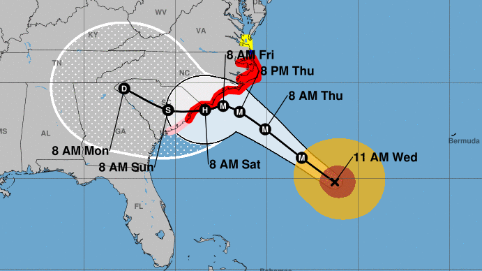
Hurricane Florence is blasting toward the Carolinas, carrying sustained winds of up to 130 mph and the threat of “life-threatening storm surge and rainfall,” the National Hurricane Center says.
A hurricane warning – meaning hurricane conditions are expected within 36 hours — is in effect for a long stretch of the coast, from the Santee River in South Carolina to Duck, N.C., which is part of the Outer Banks.
Hurricane conditions will likely hit the area around North Carolina’s southern coast on Friday, but tropical storm conditions will arrive on Thursday, according to the hurricane center.
The time to prepare for the storm is almost over, he said.
This incredible loop from #GOESEast shows Hurricane #Florence churning in the Atlantic. The storm is strengthening rapidly and is expected to become a major hurricane very soon. Latest: https://t.co/LdMJC4oIds pic.twitter.com/AqMr0P2Ogm
— NOAA Satellites (@NOAASatellites) September 10, 2018
Shortly before 11 a.m. ET, Florence was 485 miles southeast of Wilmington, N.C., moving northwest at 15 mph, the National Hurricane Center says.
The threat has sparked a rush of evacuation efforts in South Carolina and North Carolina, with more than a million people urged to get out of Florence’s way. Governors of those states have already declared states of emergency, as have the governors of Virginia and Maryland. Georgia Gov. Nathan Deal followed suit on Wednesday.
Forecasters have adjusted Hurricane Florence’s projected path, saying that after it makes landfall, it is likely to take a more southerly route than expected. Rather than pushing up toward western Virginia, the storm’s center is now predicted to move across the middle of South Carolina.
Massive waves of up to 83 feet were measured inside the storm on Wednesday, the National Hurricane Center’s Tropical Analysis and Forecast Branch said, citing satellite altimeter data.
“These enormous waves are produced by being trapped along with very strong winds moving in the same direction the storm’s motion,” the agency said.


